|
|
Trip Log
See all waypoints on a single map
or a second map displaying
all waypoints with route detail and pop-up photos.
These maps were created by
Dan Durocher and
Reid Holmes, respectively.
| day | date | endpoint |
coordinates | altitude |
distance | total | hours |
average speed |
weekly summary |
| departure | Vancouver, BC |
49.2740°N, 123.1544°W |
0 m | 0 km | 0 km | | |
|
|
| 1 | June 18 | Agassiz, BC |
49.2428°N, 121.7662°W |
30 m | 125 km | 125 km | 6:28 hrs |
19.3 km/h |
total distance cycled: 708 km |
| 2 | June 19 | Brookmere, BC |
49.8277°N, 120.9339°W |
1017 m | 114 km | 239 km | 7:20 hrs |
15.6 km/h |
total time cycling: 42.00 hours |
| 3 | June 20 | Kamloops, BC |
50.6792°N, 120.3169°W |
348 m | 142 km | 382 km | 8:11 hrs |
17.4 km/h |
days cycling: 6 days |
| 4 | June 21 | Salmon Arm, BC |
50.7090°N, 119.2369°W |
450 m | 116 km | 498 km | 7:07 hrs |
16.3 km/h |
average cycling speed: 16.86 km/h |
| 5 | June 22 | Revelstoke, BC |
50.9930°N, 118.1819°W |
458 m | 102 km | 599 km | 5:50 hrs |
17.4 km/h |
daily average distance: 118.00 km |
| 6 | June 23 | rest day |
50.9930°N, 118.1819°W |
458m | 0 km | 599 km | 0:00 hrs |
0 km/h |
average daily time cycling: 7.00 hours |
| 7 | June 24 | Donald, BC |
51.4878°N, 117.2681°W |
1082m | 109 km | 708 km | 7:04 hrs |
15.4 km/h |
degrees of longitude crossed: 5.87° |
|
| 8 | June 25 | Lake Louise, AB |
51.4165°N, 116.1780°W |
1543 m | 118 km | 826 km | 6:59 hrs |
16.8 km/h |
total distance cycled: 802 km |
| 9 | June 26 | Morley, AB |
51.1280°N, 114.6979°W |
1364 m | 135 km | 961 km | 7:19 hrs |
18.5 km/h |
total time cycling: 42.27 hours |
| 10 | June 27 | Calgary, AB |
51.0581°N, 114.0813°W |
1050 m | 46 km | 1007 km | 1:55 hrs |
24.1 km/h |
days cycling: 7 days |
| 11 | June 28 | Carbon, AB |
51.3866°N, 113.1471°W |
927 m | 101 km | 1109 km | 5:43 hrs |
17.7 km/h |
average cycling speed: 18.97 km/h |
| 12 | June 29 | Delia, AB |
51.6325°N, 112.3706°W |
910 m | 84 km | 1193 km | 5:42 hrs |
14.8 km/h |
daily average distance: 114.57 km |
| 13 | June 30 | Oyen, AB |
51.3886°N, 110.4822°W |
770 m | 141 km | 1334 km | 7:04 hrs |
19.9 km/h |
average daily time cycling: 6.04 hours |
| 14 | July 1 | Rosetown, SK |
51.5473°N, 108.0145°W |
585 m | 176 km | 1510 km | 7:34 hrs |
23.3 km/h |
degrees of longitude crossed: 9.25° |
|
| 15 | July 2 | Saskatoon, SK |
52.1265°N, 106.6502°W |
508 m | 119 km | 1629 km | 6:13 hrs |
19.2 km/h |
total distance cycled: 820 km |
| 16 | July 3 | rest day |
52.1265°N, 106.6502°W |
508 m | 0 km | 1629 km | 0:00 hrs |
0 km/h |
total time cycling: 42.80 hours |
| 17 | July 4 | Lanigan, SK |
51.8590°N, 105.0984°W |
543 m | 124 km | 1754 km | 7:34 hrs |
16.4 km/h |
days cycling: 6 days |
| 18 | July 5 | Foam Lake, SK |
51.6341°N, 103.5356°W |
581 m | 114 km | 1869 km | 7:01 hrs |
16.3 km/h |
average cycling speed: 19.16 km/h |
| 19 | July 6 | Saltcoats, SK |
51.0322°N, 102.1520°W |
528 m | 122 km | 1991 km | 7:04 hrs |
17.2 km/h |
daily average distance: 136.67 km |
| 20 | July 7 | Shoal Lake, MB |
50.4335°N, 100.5943°W |
556 m | 148 km | 2139 km | 7:24 hrs |
20.0 km/h |
average daily time cycling: 7.13 hours |
| 21 | July 8 | Portage la Prairie, MB |
49.9727°N, 98.2758°W | 266 m | 191 km | 2330 km | 7:32 hrs |
25.3 km/h |
degrees of longitude crossed: 9.74° |
|
| 22 | July 9 | Winnipeg, MB |
49.8918°N, 97.1878°W | 242 m | 81 km | 2411 km | 4:50 hrs |
16.8 km/h |
total distance cycled: 762 km |
| 23 | July 10 | rest day |
49.8918°N, 97.1878°W |
242 m | 0 km | 2411 km | 0:00 hrs |
0 km/h |
total time cycling: 42.07 hours |
| 24 | July 11 | Prawda, MB | 49.6496°N, 95.7761°W |
310 m | 111 km | 2522 km | 7:52 hrs |
14.1 km/h |
days cycling: 6 days |
| 25 | July 12 | Hawk Lake, ON |
49.8268°N, 93.9770°W |
397 m | 144 km | 2666 km | 7:34 hrs |
19.1 km/h |
average cycling speed: 18.11 km/h |
| 26 | July 13 | Dinorwic, ON |
49.6862°N, 92.4938°W |
376 m | 118 km | 2785 km | 7:04 hrs |
16.7 km/h |
daily average distance: 127.00 km |
| 27 | July 14 | Upsala, ON |
49.0432°N, 90.4716°W |
490 m | 178 km | 2963 km | 8:32 hrs |
20.9 km/h |
average daily time cycling: 7.01 hours |
| 28 | July 15 | Thunder Bay, ON |
48.4366°N, 89.2169°W |
183 m | 129 km | 3092 km | 6:12 hrs |
20.8 km/h |
degrees of longitude crossed: 9.06° |
|
| 29 | July 16 | Dorion, ON |
48.8216°N, 88.5373°W |
193 m | 78 km | 3170 km | 4:48 hrs |
16.2 km/h |
total distance cycled: 713 km |
| 30 | July 17 | Rossport, ON |
48.8377°N, 87.4460°W |
190 m | 112 km | 3281 km | 6:43 hrs |
16.6 km/h |
total time cycling: 40.33 hours |
| 31 | July 18 | Marathon, ON |
48.7167°N, 86.3632°W |
233 m | 110 km | 3392 km | 6:24 hrs |
17.2 km/h |
days cycling: 6 days |
| 32 | July 19 | Obatanga Provincial Park, ON |
48.3499°N, 85.0295°W |
422 m | 132 km | 3524 km | 7:56 hrs |
16.7 km/h |
average cycling speed: 17.68 km/h |
| 33 | July 20 | Agawa Bay, ON |
47.3240°N, 84.6101°W |
191 m | 144 km | 3668 km | 7:17 hrs |
19.8 km/h |
daily average distance: 118.83 km |
| 34 | July 21 | Sault Ste. Marie, ON |
46.5067°N, 84.3238°W |
189 m | 137 km | 3805 km | 7:12 hrs |
19.0 km/h |
average daily time cycling: 6.72 hours |
| 35 | July 22 | rest day |
46.5067°N, 84.3238°W |
189 m | 0 km | 3805 km | 0:00 hrs |
0 km/h |
degrees of longitude crossed: 4.89° |
|
| 36 | July 23 | Spragge, ON |
46.2102°N, 82.5991°W |
187 m | 164 km | 3969 km | 8:25 hrs |
19.5 km/h |
total distance cycled: 996 km |
| 37 | July 24 | Sudbury, ON |
46.4877°N, 80.9913°W |
272 m | 136 km | 4106 km | 6:53 hrs |
19.8 km/h |
total time cycling: 51.35 hours |
| 38 | July 25 | Rutherglen, ON |
46.2846°N, 79.0251°W |
203 m | 161 km | 4266 km | 7:51 hrs |
20.4 km/h |
days cycling: 7 days |
| 39 | July 26 | Deep River, ON |
46.0971°N, 77.4920°W |
146 m | 131 km | 4397 km | 7:52 hrs |
16.6 km/h |
average daily cycling speed: 19.39 km/h |
| 40 | July 27 | Fitzroy Harbour, ON |
45.4822°N, 76.2256°W |
69 m | 147 km | 4544 km | 7:38 hrs |
19.2 km/h |
daily average distance: 142.29 km |
| 41 | July 28 | Alfred, ON |
45.5787°N, 74.8402°W |
66 m | 136 km | 4681 km | 6:42 hrs |
20.4 km/h |
average daily time cycling: 7.34 hours |
| 42 | July 29 | Montréal, QC |
45.5462°N, 73.5925°W |
70 m | 121 km | 4801 km | 6:00 hrs |
20.1 km/h |
degrees of longitude crossed: 10.73° |
|
| 43 | July 30 | rest day |
45.5462°N, 73.5925°W |
70 m | 0 km | 4801 km | 0:00 hrs |
0 km/h |
total distance cycled: 940 km |
| 44 | July 31 | Champlain, QC |
46.4287°N, 72.3688°W |
18 m | 163 km | 4964 km | 7:49 hrs |
20.8 km/h |
total time cycling: 47.30 hours |
| 45 | Aug 1 | Berthier-sur-Mer, QC |
46.9474°N, 70.6614°W |
38 m | 170 km | 5134 km | 8:58 hrs |
19.1 km/h |
days cycling: 6 days |
| 46 | Aug 2 | St-Antonin, QC |
47.7676°N, 69.4401°W |
184 m | 153 km | 5287 km | 7:43 hrs |
19.8 km/h |
average daily cycling speed: 19.87 km/h |
| 47 | Aug 3 | Grand Sault / Grand Falls, NB |
47.0459°N, 67.7325°W |
136 m | 165 km | 5452 km | 7:47 hrs |
21.2 km/h |
daily average distance: 156.67 km |
| 48 | Aug 4 | Woodstock, NB |
46.1298°N, 67.5776°W |
45 m | 124 km | 5576 km | 7:03 hrs |
17.7 km/h |
average daily time cycling: 7.88 hours |
| 49 | Aug 5 | Mill Cove, NB |
45.8980°N, 66.0169°W |
59 m | 165 km | 5741 km | 7:58 hrs |
20.7 km/h |
degrees of longitude crossed: 7.58° |
|
| 50 | Aug 6 | Cap-Pelé, NB |
46.2317°N, 64.2924°W |
7 m | 159 km | 5900 km | 7:11 hrs |
22.1 km/h |
total distance cycled: 731 km |
| 51 | Aug 7 | Stratford, PEI |
46.2273°N, 63.1042°W |
9 m | 108 km | 6008 km | 5:53 hrs |
18.3 km/h |
total time cycling: 38.63 hours |
| 52 | Aug 8 | Antigonish, NS |
45.6302°N, 62.0023°W |
15 m | 131 km | 6138 km | 7:02 hrs |
18.6 km/h |
days cycling: 6 days |
| 53 | Aug 9 | Whycocomagh, NS |
45.9673°N, 61.1040°W |
33 m | 103 km | 6242 km | 6:26 hrs |
16.0 km/h |
average daily cycling speed: 18.92 km/h |
| 54 | Aug 10 | North Sydney, NS |
46.2008°N, 60.2575°W |
6 m | 92 km | 6334 km | 4:49 hrs |
19.1 km/h |
daily average distance: 121.83 km |
| 55 | Aug 11 | rest day (ferry to Argentia, NL) |
46.2008°N, 60.2575°W |
6 m | 0 km | 6334 km | 0:00 hrs |
0 km/h |
average daily time cycling: 6.44 hours |
| 56 | Aug 12 | St. John's, NL |
47.5659°N, 52.7041°W |
9 m | 139 km | 6472 km | 7:17 hrs |
19.0 km/h |
degrees of longitude crossed: 13.31° |
GPS coordinates are listed in decimal latitude-longitude NAD 83.
Note, I realized my odometer setting was
off by 2% upon verifying the calibration
in Manitoba (for every 1000m I cycled my odometer recorded 980m).
To get more accurate values, all distances should be multiplied by 1.02.
|
Route
| from | to | road |
distance |
| Vancouver, BC | Hope, BC | Highway 7 - Lougheed Highway
(1)
(2)
(3)
|
156 km |
| Hope, BC | Merritt, BC |
Highway 5 - Coquihalla |
123 km |
| Merritt, BC | Kamloops, BC |
Highway 5A | 86 km |
| Kamloops, BC | Calgary, AB |
Highway 1 - Trans-Canada |
620 km |
| Calgary, AB | Saskatoon, SK |
Highway 7 |
620 km |
| Saskatoon, SK | Winnipeg, MB |
Highway 5 - Yellowhead
(1)
(2)
|
779 km |
| Winnipeg, MB | Thunder Bay, ON |
Highway 1, 17 - Trans-Canada |
692 km |
| Thunder Bay, ON | Sault Ste. Marie, ON |
Highway 17 - Trans-Canada |
698 km |
| Sault Ste. Marie, ON | Arnprior, ON |
Highway 17 - Trans-Canada, Highways 22, 9, Ottawa River Parkway
(1)
(2)
(3)
|
800 km |
| Ottawa, ON | Montréal, QC |
Highways 34, 174, 148
(1)
(2)
(3)
(4)
|
199 km |
| Montréal, QC | Québec, QC |
route 138 |
260 km |
| Québec, QC | Rivière-du-Loup, QC |
Route 132 |
207 km |
| Rivière-du-Loup, QC | Edmundston, NB |
Route 185, Highway 1 - Trans-Canada |
118 km |
| Edmundston, NB | Moncton, NB |
Highways 2,
105, 103, 2, 102, 105, 112, 106
|
444 km |
| Moncton, NB | Charlottetown, PEI |
various |
165 km |
| Charlottetown, PEI | Wood Islands, PEI |
various |
53 km |
| Wood Islands, PEI | Caribou, NS |
ferry |
75 minutes |
| Caribou, NS | North Sydney, NS |
Highway 104, 105 |
280 km |
| North Sydney, NS | Argentia, NL |
ferry |
14 hours |
| Argentia, NL | St. John's, NL |
Highway 100, 1 |
131 km |
The table above gives a rough idea of my route. There are instances where I
took side roads instead of the main highway, in which case
my route differs from that indicated by Google maps.
This is especially true in urban areas.
My route involved a series of smaller roads parallel to
the highway throughout most of New Brunswick and P.E.I.
You can see my exact route on this map
(does not work on all browsers).
There are multiple reasons for which I may not get far on this bike trip:
- I have a tendency to make overly-ambitious trip plans.
- Previous to this trip, the longest distance I had cycled
was 170 km over two days.
- I am likely to miss Andrea after a day or two alone on the road.
- My back, knees, and IT bands have caused me problems in the past.
Eight weeks of cycling might not improve things.
- I'm riding a mountain bike instead of a road, touring, or hybrid bike.
- There are many mosquitoes in Canada.
- Two months is a long time.
- Canada is a big country.
Statistics
It turns out I made it. Here are a few statistics for those who care.
| A | total distance cycled | 6472.2 km |
| B | total time cycling | 347.11 hours |
| C | duration of trip | 56 days |
| D | days cycling | 50 days |
| E | average cycling speed | 18.65 km/h |
= A / B |
| F | daily average distance | 129.44 km |
= A / D |
| G | overall daily average distance | 115.58 km |
= A / C |
| H | average daily time cycling | 6.94 hours |
= B / D |
| I | provinces visited | 10 | |
| J | time zones visited | 6 | |
| K | degrees of longitude crossed | 70.45° | |
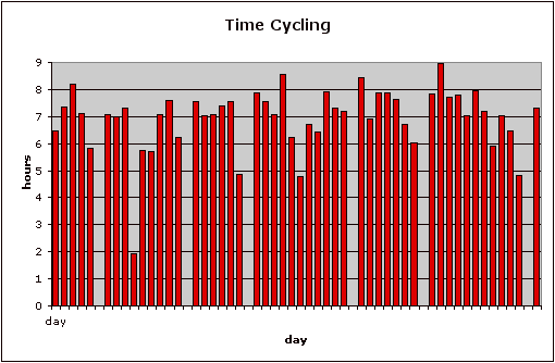
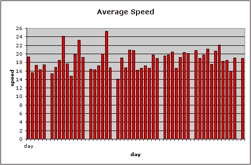
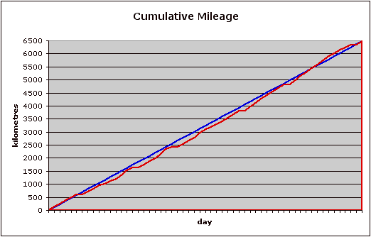
The data from the first table is plotted below.

|
|