Great Divide Trail: Kananaskis Lakes to Field
The Great Divide Trail straddles the continental divide (the lower BC-Alberta border) for over 1000 kms starting from Waterton Lakes and extending north of Jasper into the Willmore Wilderness. From July 23 through 31, 2005, I hiked the central 221 km of the trail from Kananaskis Lakes to Field, passing through three national parks (Banff, Kootenay, and Yoho) and four provincial parks (Peter Lougheed, Height of the Rockies, Spray Valley, and Mount Assiniboine).

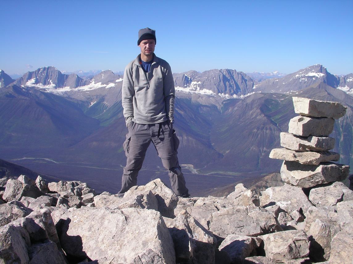
The terrain along the trail includes hundreds of opportunities to visit nearby peaks. I took advantage of these and made several side trips to nearby summits for a total distance travelled of 272 km with seven peaks climbed. I had considered climbing one or both of Assiniboine and Sir Douglas, but the snowy conditions this season and the need to carry additional gear made me decide against these and instead to travel light and focus on some of the many dry scrambling routes.

The weather was amazing; it was sunny for almost the entire time, except my first night camped at the Mount Sarrail campground near Upper Kananaskis Lake and again on my fifth night which happened to be my only night spent under a roof when I stayed in the Hind Hut at Mount Assiniboine. Not once did I need to wear my rain jacket.

I had originally planned on continuing north of Field into the Little Yoho Valley for some additional scrambling. After spending a night on the riverbank in Field, the appeal of a shower, a beer, and seeing my lovely wife Andrea proved too strong, so I stuck out my thumb and hitched a lift to Calgary.

map: Click to see a larger image of the trail with campsites and summits indicated.
Day 1: Kananaskis Lakes to Turbine Canyon
distance hiked: 26.5 km
peaks summited: Indefatigable, 2670 m, North to South Traverse
I left the Mount Sarrail campground at 8:00 am and hiked along Upper Kananaskis Lake to the Mount Indefatigable trailhead at 9:15 am. I left my pack here and headed up the trail to the north summit and traversed across to the south summit as described in Kane's guidebook. The traverse is excellent, follows a solid ridge line that's low on exposure, presents great views of Kananaskis Lakes and the surrounding peaks, and requires little time to complete. The descent was quick and I was back at my pack by 1:15 pm.
photo: the south summit of Indefatigable as seen from the north summit, behind lies Upper Kananaskis Lake
The views from the trail through Peter Lougheed seemed to change rapidly; the trail climbed through several valleys bordering on dozens of peaks as I hiked higher up along it. I took an enjoyable break near Lawson Lake before continuing to the nearby Turbine Canyon where I arrived at 7:00 pm. The site is named after the deep rock canyon through which water rushes near the campsite. Here I met some nice folk from Saskatoon (can't remember their names!) who were continuing on the next morning to hike a loop over the North and South Kananaskis Passes.
photo: taking a rest at Lawson Lake
Day 2: Turbine Canyon to Birdwood
distance hiked: 29 km
The bugs woke me early. After trying to fall back asleep I was packed and hiking by 7:30 am. After hiking over North Kananaskis Pass into Height of the Rockies Provincial Park in BC, the trail descends along LeRoy Creek to its confluence with the Palliser River. The trails in Height of the Rockies are not maintained and the trail that forks north is almost non-existent. After searching for the best-looking trail for almost one hour, I followed what turned out to be a game trail that soon faded. Three hours of bushwhacking and six river-crossings later, I had only advanced 2 km. I finally located the correct trail and headed up Palliser Pass (steep), across the swampland of the southern Spray River valley, and finally to the Birdwood campsite at 6:00 pm. The trailside views of Mount Sir Douglas and Mount Birdwood were both impressive.
photo: Park rangers use horses to access the remote cabins like this one on the right that lies just south of the Birdwood campsite.
Day 3: Birdwood to Allenby Junction
distance hiked: 35.6 km
peaks summited: Shark, 2786 m, North Ridge
I awoke to frost on my tarp and bivy sack and ice on my water bottle. Although I had been chilly overnight, the sub-zero drop in temperature meant the mosquitoes had disappeared around midnight and would not reappear until after 9:00 am. Just a dozen metres from my tent site were elk, deer, and moose grazing in the meadows and on nearby shrubbery. I was hiking by 8:30 am and quickly headed into the busier corridor of Banff. At 11:15 am I left my pack under a bridge and headed east into Spray Valley Provincial Park to scramble the North Ridge of Mount Shark. I had considered visiting the nearby summits of Mount Smuts and The Fist, but these required several kms of bushwhacking; I'd had enough on the previous day and decided to stick to the trails.
photo: following the north ridge of Mount Shark
Well mostly. After following a short trail to a spring, the approach to Mount Shark involves a short uphill bushwhack to gain the ridge. The scrambling is very pleasant on the way up, especially after reaching the first hump and following the ridge crest over the many false summits to the top. As Kane writes, the views were indeed breathtaking. All of the peaks in the Spray Lakes area are visible, as are Sir Douglas to the south and Assiniboine and its neighbours to the west. The descent was pleasant save perhaps the last 100m off the ridge back into the trees (loose rock here). I took Kane's suggestion on the bushwhack downhill and simply navigated with my ears back to the spring. I was back at my pack at 5:15 pm and hiking westward, stopping at the Allenby Junction campsite at 7:30 pm. As had been the case on the previous evening, I again had the campsite all to myself.
photo: Looking south from the summit of Mount Shark, one sees Mount Smuts (left), Mount Birdwood (sharp spire behind Smuts), and Mount Sir Douglas (tall peak at back).
Day 4: Allenby Junction to Hind Hut
distance hiked: 19.1 km
peaks summited: Wedgwood, 3024 m, South Face
peaks summited: Strom, 3022 m, Southeast Ridge
This morning I slept in until 7:00 am (I was not setting an alarm). Again the temperature had dipped below zero and there was much frost on my bivy sack and tarp. I decided to laze around until the sun hit the valley bottom and melted the frost somewhat before packing camp. After a late departure at 9:15 am, I headed west over Assiniboine Pass and I arrived at Assiniboine Lodge before noon under clear blue skies. The friendly staff at the lodge gave me my food resupply which I'd had flown in.

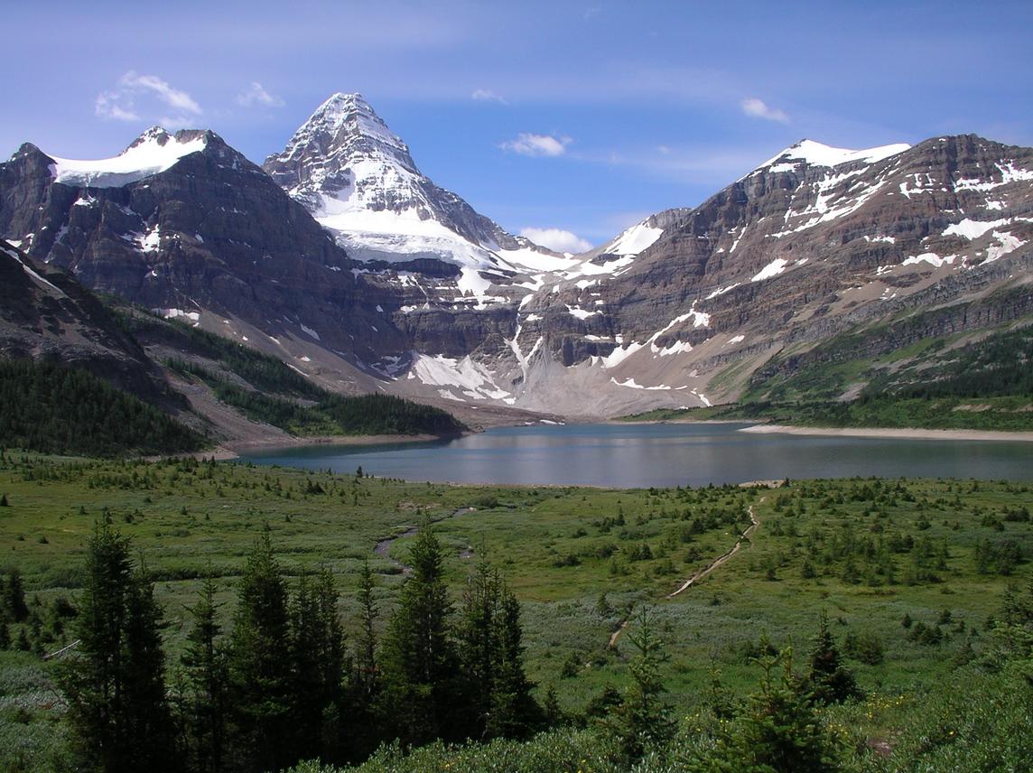
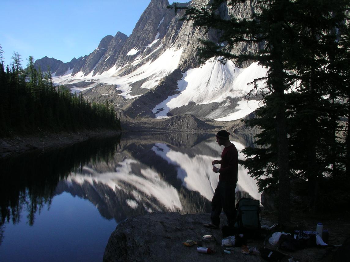
I decided to spend a day on a side trip up to Mount Assiniboine. After leaving some extra food and gear at the lodge I headed up the headwall at 12:15 pm. As the Corbett guidebook warns, the path along the Gmoser Highway is sketchy in places. It's exposed to say the least and requires attentive footwork much of the way. I reached the Hind Hut at 2:45 pm. During the last hour up, the skies clouded over, the wind picked up, and a light rain fell now and then. I stopped in the hut, unpacked, ate some lunch, and rested for half an hour.

photo: Here is the famous view of Assiniboine as seen from the lodge. Mount Wedgwood is the taller peak right of Assiniboine with snow below its summit. Mount Strom is visible between Wedgwood and Assiniboine, partly hidden behind Wedgwood.
At 3:20 pm I re-emerged and headed up the scree on the south face of Wedgwood. I considered traversing directly from Wedgwood to Strom on the ridge that connects them but changed my mind after examining the snow slope (it would have been fine with boots and an ice axe but I lacked both). I headed back down to the hut and then around west up the southeast ridge of Strom. Visibility was somewhat limited although Assiniboine remained mostly in view. Snow and hail fell at the higher elevations. I was back at the hut at 5:50 pm, both ascents having required a total of only two and a half hours return from the hut.

Inside I met Jack and Art, two American climbers. I got an idea of their age when Jack mentioned that the youngest of his three children had been born in 1961. This pair was the real deal: no harnesses, just three wraps of the rope for a swami belt, a good old hip belay, and webbing for rock protection. These hardmen summitted almost every peak in the area during their stay (including Sturdee and Lunette amongst others). As I asked questions, I learned about a first ascent here, another three there, an expedition to the Himalaya, ... Unfortunately, I never caught their surnames.

photo: the Hind Hut and the north ridge of Assiniboine on the left horizon
I enjoyed spending a night in an environment free of bugs and free of the constraints of my bivy sack. Like other ACC huts, this place was luxurious with its propane stove, dishware, and foam mattresses. As the rain fell and the wind blew (again, I was happy not to be bivying) I radioed the lodge to get a weather forecast for the morning: sunshine they promised. This seemed unlikely.
Day 5: Hind Hut to Howard Douglas Lake
distance hiked: 30.2 km
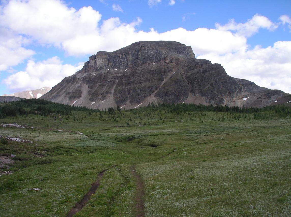
peaks summited: Citadel, 2625 m, Northeast Ridge
The weather forecast proved correct. The clouds burned off early in the morning and the skies were clear by 6:30 am. I was relieved since I much preferred descending the headwall under dry conditions. I left the hut at 7:15 am and was back at the lodge by 9:15 am. I retrieved my food and gear and repacked. I had enjoyed the smaller pack as my food had become lighter but now I was back to a full load.

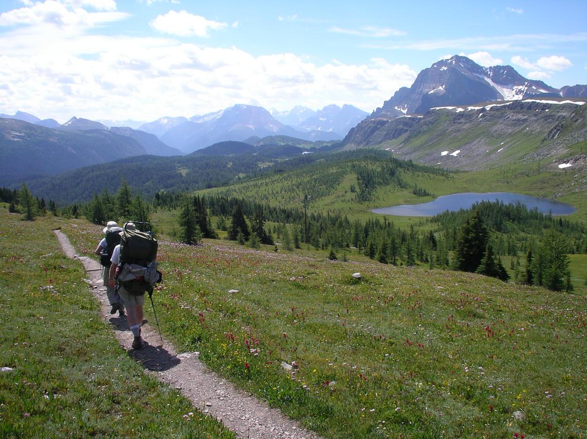
I left the hut by 10:15 am and hiked north. Og Lake is beautiful; consider staying at this campsite if you're in the area (in general, the campsites in Banff are under tree cover, away from any interesting views, quite the opposite of the panoramas visible from most campsites in Mount Assiniboine and Kootenay). The next stretch through the Valley of the Rocks is very dry. In fact, the only water source between Og Lake and Citadel Pass is a single small lake where I stopped for lunch and enjoyed a swim. If you pass this way, make sure to fill up on two or more litres of water before leaving Og Lake.

photo: The Valley of the Rocks north of Og Lake is very dry (but bug-free). Assiniboine remains visible throughout the entire region.
The climb up to Citadel Pass seemed long. I was happy to reach a tarn up high as the grade eased. After filling my bottle (and purifying my water for the first and only time on the trip) I headed along the remaining two kms of flat trail to the pass. From there, a quick scramble up Citadel Peak took less than one hour of effort. Again, the views! Amazingly, the Bugaboos were clearly visible to the west: Howser, Snowpatch, and Bugaboo. To the north Mount Ball looked imposing, while Assiniboine dominated the south, and Sir Douglas was still in sight to the southeast. I considered visiting Fatigue Mountain across the pass but decided instead to head down.

A leisurely hike downhill led to the Howard Douglas Lake campsite at 6:00 pm. I would have liked to continue walking, but the next campsite was Healy Creek, about fifteen kms further. I considered continuing to Sunshine but decided against it. (When I arrived in Sunshine the next morning, someone was indeed camped near the lake).

photo: Citadel Pass lies at the left col. The easy route to the summit of Citadel Peak follows the left horizon, along the easy lower slopes, up fun unexposed third class rock, and then to the summit along an easy scree ridge.
Day 6: Howard Douglas Lake to Ball Pass Junction
distance hiked: 36.8 km
peaks summited: Pharaoh, 2713 m, Southwest Face
After another buggy night (no sub-zero temps anymore, even though I was camped at 2200 m) I woke early and was hiking by 6:15 am. I hoped the healthy start time would allow me to get to Egypt Lakes by noon. Instead, I got lost on the golf-course hiking trails around the Sunshine ski resort and unintentionally hiked an additional 5km loop. After orienting myself, I headed up to Simpson Pass and across beautiful blossomed meadows up to Healy Pass where I had lunch. The trail wove back and forth across the provincial border all morning, crossing yet another border marker every few kms.

I arrived at Egypt Lakes in the early afternoon and headed up toward Whistling Pass. I had my eye on Pharaoh Peak and shortly before the pass I cached my pack and headed up the southwest face. I started scrambling easy third class rock but the uncertain route soon led me to move around left onto the straightforward scree slopes.

photo: the view southeast from Healy Pass
After descending from Pharaoh Peak, I enjoyed a longer break at Whistling Pass since I only had 5km downhill remaining before the campsite; the persistent wind (hence the name) meant there weren't any bugs around. I did well to rest here since the bugs were indeed horrible down below when I arrived at 7:00 pm. My feet were sore; after examining them I realized I had an infected in-grown toenail on one foot and a blister on the heel of the other. After eating, I washed my feet in the river, put on fresh clean socks, and went to bed. The bugs remained awful, preventing sleep for the first few hours. Later a rodent made repeated visits, chewing on my pack and shoes until I scored a perfect hit with a baseball-sized rock, causing the annoying visitor to run away for the remainder of the night.
photo: Pharaoh Peak as seen from the east
Day 7: Ball Pass Junction to Floe Lake
distance hiked: 28.9 km
peaks summited: Isabelle, 2938 m, South Face
I had set the alarm for the first time this week: 5:00 am. I was meeting James at 3:00 pm at the Floe Lake trailhead and I wanted to climb Mount Isabelle before then. Given my poor sleep the previous evening, I felt particularly tired and I considered sleeping on, in the end deciding to rise. I was hiking by 6:30 am and was pleasantly surprised by the low effort required to cross Ball Pass. Shortly after, I cached my pack near the trail and started up Isabelle. The ascent follows a drain gully that is surprisingly free of loose rock. After gaining its top, the talus ridge is followed to a short, somewhat steeper, but solid section to the summit. Again, views of the Bugaboos, the Goodsirs, the Rockwall, etc.

I was back at my pack at 11:45 am. Along the way out, I stopped by a stream and cleaned out my infected toe. Quite satisfied with the result, my left foot felt much better on the hike out and I arrived at the Floe Lake trailhead just before 2:00 pm. Here I lay in the shade and awaited James who arrived at 3:00 pm.

photo: Isabelle summit self-portrait on the Banff-Kootenay boundary. Behind lies highway 93 and the Floe Creek trailhead where I would meet James.
It was great to see James. I'd been hiking alone for seven days and meeting a good friend on the trail was exciting. After repacking (James brought me food, clean clothes, charged batteries, etc.) we headed up the steep trail to Floe Lake which we reached around 7:00 pm, a gorgeous location for a campsite. The bugs seemed much better on this side of the valley. Furthermore, I was rewarded with the luxurious bug-free haven of James' tent for the next two evenings. That night I enjoyed my best sleep of the week.
Day 8: Floe Lake to Helmet Falls
distance hiked: 28.8 km
After a great sleep, we rose shortly after the alarm woke us at 7:00 am, enjoyed breakfast by the beautiful Floe Lake, and were hiking by 8:45 am. James unfortunately suffered painful blisters inflicted by his old hiking boots. No amount of second skin, tape, or gauze seemed to help. James trucked on, however, as we hiked most of the Rockwall trail in a single day. James treated me to a delicious lunch of fresh avocado, cheese, tuna, and salsa on tortilla. We enjoyed tremendous views the entire day, especially along the final 10 km. We arrived at the Helmet Falls campsite (huge waterfall) at 7:30 pm, where, although fatigued, we enjoyed our bug-free dinner.
photo: James heats water for breakfast by Floe Lake.
Day 9: Helmet Falls to Field
distance hiked: 37.5 km
Since neither of us had a big day planned, we rose later, visited Helmet Falls, and started hiking at 9:45 am. Shortly after leaving camp, James and I parted ways, as he headed back to Highway 93 via the Paint Pots and I continued north toward Highway 1 and Field. The trail soon reached Goodsir Pass, providing nice views of the Goodsirs across the valley. The hike downhill to the highway was rather uneventful, almost monotonous, as the trail joins an old road grade halfway between the pass and the highway. The sun was blasting and I had to make sure to fill my water often. I stopped to chat with a friendly park ranger at the McArthur Creek ranger station.

I had the option of staying at two campsites along the way, but decided to continue to the highway which I reached at 5:00 pm. Here, I continued walking the 8 km along the highway to Field. I arrived tired, with feet aching from the hard ashphalt, after covering 37 km. In Field I visited the park office where the staff were particularly unhelpful. I then wandered the town, stopping to buy a litre of orange juice and half a litre of milk. I definitely looked out of place with the Audi-driving crowd arriving for dinner at the Truffle Pigs restaurant in front of which I sat on a park bench, slurping orange juice, wearing duct-taped and stained pants, looking greasy, dirty, and very tired. I didn't help that I took my shoes off to let my feet breathe.

photo: the Goodsirs as seen from the Ottertail River trail north of Goodsir Pass
After visiting the store a second time to buy dinner food, I followed the railroad out of town along the river bank where I found a nice flat spot to let out my bivy sack. The weather had been perfect for many days and I didn't bother with the tarp. I enjoyed the perfect starry sky and decided I would head home the following day.
Equipment
Pack weight was a key factor in deciding what to bring on my hike. My pack weighed 8.6 kg without food, water, or fuel, and 14.7 kg with 1 litre of water, 4 days of food, and 7 days of fuel.
pack
I used my trusty Arc'Teryx Khamsin 38 pack (1275 g) and a 2L side pocket. When heading off the trail on a scramble, I slung the side pocket over my shoulder and brought a tuque, warm shirt, water, food, guidebook, gps, camera, sunscreen, sunglasses, and knife.
campsite
I decided not to bring a tent and instead brought the Integral Designs Microbivy (455 g) along with the Integral Designs Siltarp (200 g). I used my Europe Bound +2°C down bag (550 g), an MEC silk liner, a light Therm-a-rest, and a light bug net over my head. This system worked very well as rain shelter, was relatively warm, and breathed surprisingly well, but the setup was definitely inferior to a tent when it came to bug shelter and comfort.
cookware
For cooking I used the GSI 1L and 500 mL pot set (312 g), the MSR Whisperlite stove (305 g), one 650 mL MSR fuel bottle, a lexan spoon, and a swiss army knife.
poles
I brought Komperdell Titanal Duolock trekking poles which were great not only for hiking, but also for propping up the tarp, river crossings, and for self-arrest on snow slopes (although highly inferior to an ice axe in this capacity).
footwear
I bought a pair of Asics Trail IV specifically for this trip. These worked extremely well on most terrain: scree, talus, snow, slab, mud, water, and of course on dirt trail. When in snow I used a pair of sock gaiters which kept most of the snow out. Of course the shoes did get wet in snow and water, but they would dry within a few hours, much sooner than a pair of boots would dry. The shoes resisted surprisingly well to the rough rock terrain on the scrambles and I would definitely buy the same pair again. I wore foam flip flops on the river crossings and around camp in the evenings.
clothing
I had one pair of pants with zip-off legs, two pairs of socks, one t-shirt, one long-sleeved shirt, a soft-shell fleece, underwear, long underwear, a fleece tuque, fleece gloves, a sun hat, and a nylon rain poncho.
navigation
I had with me the relevant sections of the Lynx and Kane guidebooks (see below) and the four Gem Trek maps of the area. I carried a gps and compass but rarely used either.
Logistics
permits
I obtained an annual backcountry permit from Parks Canada and reserved sites in Banff, Kootenay, and Yoho. Over half the nights I did end up staying where I'd planned to. It wasn't much of a problem since other than a few popular sites (like those on the Rockwall) there were very few people camped in the parks (even though it was a warm and sunny July).
transportation
James gave me a lift from Calgary to the Mount Sarrail campground in Peter Lougheed Provincial Park the night before I began the hike. A Greyhound bus passes through Field three times daily in each direction along Highway 1.
food resupply
I had 8 pounds (3.6 kg) of food helicoptered from Canmore to Assiniboine Lodge at a cost of $12. Contact Assiniboine Lodge for details. I dropped off a stuff sack of food at the Canmore heliport the evening before my hike. James brought me my second food drop with fuel at the Floe Lake trailhead. After seven days, I still had close to half of my original 650 mL of fuel (that's with daily hot dinner, soup, hot apple cider, and hot breakfast every second day). Also, food and fuel are available for purchase at either end in Kananaskis and Field.
water purification
I brought Polar Pure iodine crystals with me. Most of the water sources were fast-flowing clean meltwater, at high elevation, close to a snow source. Consequently, I only purified my water once when I took water from a tarn.
bugs
Other than the last few days in Kootenay and Yoho, the higher elevations around the Hind Hut, and the dry Valley of the Rocks north of Assiniboine, the bugs were heavy. They were annoying around the campsites and I didn't get much chance to lounge around and relax in the evenings before bed because of this.
photo: I took this photo on the way out from the Hind Hut on the Gmoser Highway. The indistinct path follows near the base of the rockband from left to right.
bears and rodents
I didn't see any bears but I came across the occasional scat and paw print. All sites I stayed at (except the last night in Field) were equipped either with a metal food box or cables for hanging food. Rodents were a nuisance only at the Ball Pass Junction campsite.
references
Return to Steph's Homepage