|
| ||
| President elevation: 3138m approach: Emerald Basin ascent route: east ridge - YDS grade II descent route: east ridge elevation gain: 1830m (from Emerald Lake) time: 12.5h
|
Vice-President elevation: 3066m approach: Emerald Basin ascent route: west ridge - YDS grade II descent route: west ridge elevation gain: 190m (from President Col) time: 12.5h
|
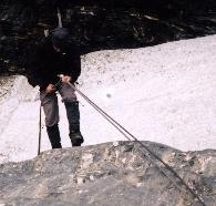 | The Presidents appear to the northwest of the Trans-Canada, a few kilometres southwest of Field. The range lies behind Emerald Lake in the middle of Yoho National Park. After a late start due to overcast weather and a "faulty alarm clock", the clearing skies encouraged us to proceed with our planned ascent, hoping the clouds would continue making way for more blue. The Presidents provide an easier climb over a frequently alternating mixture of snow and rock. We headed into the Emerald Basin and up a snow couloir to the head of the glacier. From there, some enjoyable class 3 scrambling over stair-like rock leads onto the glacier, avoiding the steep ice at its base. A pleasant, winding route up the glacier easily leads to the col. A scramble up the east ridge of the President meets the short icy, corniced summit ridge. For the Vice-President, a fun climb on increasingly steep snow leads to the top of the west ridge. |
